Services
Local History
Information about the history of Pauntley
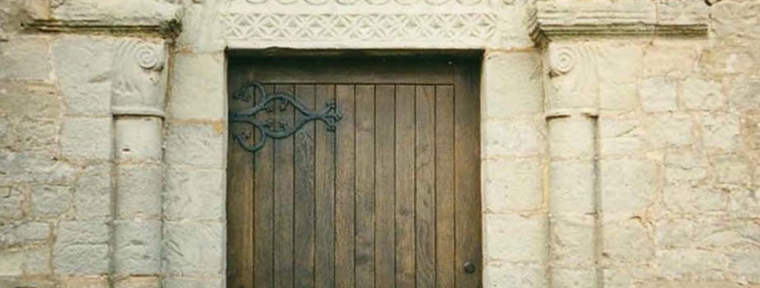
Pauntley is well-known as the probable birthplace of Dick Whittington, whose family owned the manor house here, Pauntley Court, at the time of his birth in the 14th century. Adjacent to the Court is the church of St John the Evangelist with its fine Norman south doorway, with a chevron arch and a carved tympanum of the Dymock school.
Although a small Parish, Pauntley has a wealth of historical buildings and places of interest and this part of the website aim to give readers an insight to some of these sites and the role of the parish at significant times in history.
Boundary Markers
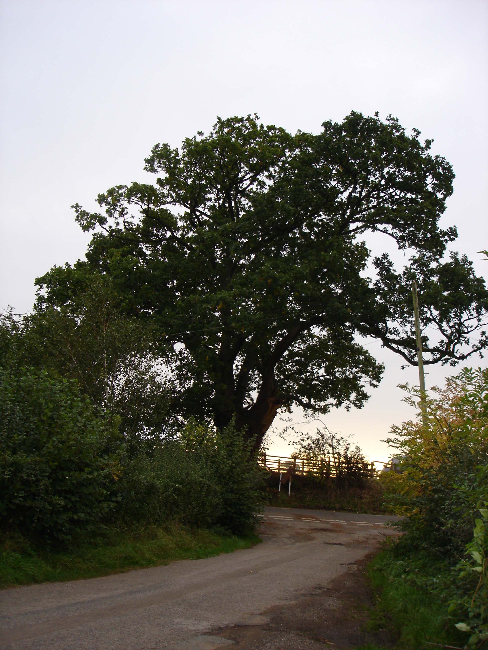
In rural areas such as Pauntley, natural features such as trees or rivers often formed the boundaries of the parish. The River Leadon forms the boundary of Pauntley on its north and east with Dymock and with Redmarley. Pauntley also has several large trees which were planted to act as boundary markers. Perhaps the most prominent of these is the large pollarded oak tree just outside Pauntley C of E Primary School. It marked the boundary between Pauntley parish and Newent parish at this point, which was an important factor in the siting of the school. This boundary, which at one time bisected Pool Hill, was altered late in the 20th century so that Pool Hill now falls entirely within Pauntley. Although this tree is itself several hundred years old, it has replaced the original (or possibly even several originals) that would have been planted at this point.
The Church of St John the Evangelist
Our lovely Norman church is set in a peaceful and elevated setting close to Pauntley Court. Pauntley Court was the home of the Whittington family from the 14th century and believed to be the birthplace of Dick Whittington, who was presumably baptised here in Pauntley Church. The church is well-known for its beautiful south doorway of the Dymock school of carving.
For more information, including the survey of memorials and and inscriptions at the church, and for details of services and other events, please see the church’s website www.pauntleychurch.btck.co.uk
Pauntley Memorial Inscriptions
Brenda Bainbridge has made a survey of the memorial inscriptions in Pauntley, which can be viewed on the website of the Forest of Dean Family History Society. [Link opens in a new tab]
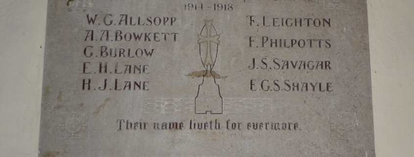
Inside the parish church of St John the Evangelist in Pauntley, Gloucestershire, on the south wall, is small memorial tablet commemorating the men of the parish who died in the First World War. It is not a grand monument like some war memorials, and is very simply and plainly executed. Only the initials and surnames of the men are recorded, together with a simple inscription.
A few documents of the Diocese of Gloucester survive, telling the story behind the erection of this memorial tablet. They tell of a petition dated 4 April 1920, filed in the Consistorial Court of Gloucester by the Reverend William Swain Irving, Vicar of Oxenhall with Pauntley, “for a grant of a faculty for:
1. The erection of a memorial tablet of Hopton Wood Stone on the South Wall of the Parish Church of Pauntley, in memory of those of the Parish who made the supreme sacrifice for their country in the Great War, 1914-1918, and to bear the following inscription:
In Memory of those of this Parish who made the
supreme sacrifice for their Country in the Great War
1914-1918
W.G.Allsopp F.Leighton
A.A.Bowkett F.Philpotts
G.Burlow J.S.Savagar
E.H.Lane E.G.S. Shayle
H.J.Lane
Their name liveth for evermore
2. The placing of a pair of brass standard candlesticks in the chancel of the Parish Church of Pauntley.”
The petition was approved at a vestry meeting of 16 March 1920, certified by Rev’d Irving, the Parish Warden John L Stelfox, the Diocese Warden Thomas Stelfox and Major William Thackwell. The cost was to be met by public subscription of £25 and the remainder was to be paid for by the Rev’d Irving, who also paid for the candlesticks as his ‘personal offering’. The petition was approved and stonemasons Friths of Gloucester were commissioned to carry out the work, their brief sketch plan for the tablet appearing in the documents. The Rev’d Irving was at the time vicar of both Oxenhall and Pauntley, living at The Vicarage, now Oxen Hall, in Oxenhall. As owners of the Walden Court Estate, the Stelfoxes were important landowners in the parish. Major Thackwell, who lived at The White House, was also a prominent local figure and Justice of the Peace.
The memorial was unveiled and dedicated on Sunday 19 June 1920. A short report of the event appeared in the Gloucester Journal of Saturday 26 June 1920, as follows:
UNVEILING OF WAR MEMORIAL
“St John’s Church, Pauntley, was crowded with parishioners and friends on Sunday, when the Rev. Gethyn Jones (curate of Newent) preached the dedication sermon at the unveiling of the memorial tablet which has been erected by public subscription, and which bears the following inscription: To the memory of those of the parish who made the supreme sacrifice for the country in the Great War, 1914-1918. W.G.Allsopp, A.A. Bowkett, G. Burlow, E.H. Lane, H.J. Lane, T. Leighton, F. Philpotts, I.S. Savagar (sic), E. Shayle. ‘Their name liveth for evermore’. This design was carried out by Mr Arthur Frith, sculptor, of Gloucester. It is of polished Hopton Wood stone and harmonises most appropriately with the surroundings.”
The little church would indeed have been crowded, as the report indicates, if all the families in the parish were present, as the small church presently seats about 90 at most – about half of the population of the parish at the time. Perhaps there was also a choir, as there was certainly one in the 1940s when the young Anne Solesbury (nee Hinds) was a member along with about 10 other boys and girls. However, we have to imagine the scene as, sadly, no photograph was included with the report and none has yet come to light from any other source.
A book telling the story of the men commemorated on our war memorial, price £5.95, is available from Lesley Harding at michaelw600w@btinternet.com. All proceeds go to Pauntley Church.
Pauntley in 1086
The first documentary reference to Pauntley and the other areas which make up the later parish is in Domesday Book in 1086. There are no Anglo-Saxon charters surviving for this part of Gloucestershire and no other surviving records before this time. However, place-names in the parish indicate earlier settlement here. The name “Pauntley” or “Pantelie” comes from the Welsh pant(valley) and Old English leah (normally a clearing in woodland). Much of the West Midlands was well-wooded in the Anglo -Saxon period following woodland regeneration at the end of the Roman period and it seems likely that, in this part of the country, leah indicated an area that was predominantly wooded when the place name first evolved. At the time of Domesday, “leah” as a parish name seems to indicate an area which was not undeveloped and may already have been a settled . References to enclosures (“haga”, as in Hayes and Harridge), together with this leah element in Pauntley, suggest a wooded landscape with clearings for pasture and fencing for control of stock.
The topographical nature of this place-name also suggests an early naming of Pauntley, perhaps between AD 400 and 700. This and other place names in the area also show that British influence was strong here during this period. The River Leadon (or Ledene) probably derives from Welsh llydan, meaning broad. Many other place-names in the surrounding area are of Welsh origin. Dymock, probably from the Welsh ty moch, meaning swineherd’s hut or cottage (again suggesting this originated as a clearing in a wooded area) and Compton Green, just outside Pauntley parish boundary, from the Welsh cwm (valley) and OE tun (farmstead). The Saxons may not have reached this part of Gloucestershire until around the 7th century and a British enclosure may have continued to survive during this period in the Newent/Dymock area. Welsh may therefore have been spoken in this area well into the Saxon period.
In the 7th and 8th centuries AD, the area west of the Severn and the Leadon was in Herefordshire and Pauntley would have been part of the territory of the Magonsaetan, extending from the Severn in the north to the Wye in the south, with the Wyre Forest, the Malverns and the River Leadon as the eastern boundary. The Magonsaetan had a strong British element in their identity, strengthening the view that this part of Gloucestershire retained its British identity into the Saxon period.
Several of the other place-names in the parish have their origins in Old English, many from personal names, such as Kilcot (Cylla’s Cottage), Payford (Paega’s Ford), Ketford (possibly Cydda’s Ford), Botloes Farm (from the hlaw or burial mound of Bota), Aylesmore (personal name Aegel and mor or barren waste land) and Rylas or Rhyle House, first recorded in 1317 (ryge leah or rye clearing). On the parish boundary with Redmarley, Durbridge derives from OE deor brycg or deer bridge (possibly also an early ford name). The frequency of Old English personal names, particularly attached to boundary points, indicates a man-made landscape at the time of naming and therefore an already settled and farmed landscape. These elements are present in Pauntley on the boundaries at Payford, Ketford and Botloes’ Green. The use of personal names to name fords at Payford and Ketford also suggests that the individuals who owned these fords also owned the estates in which they lay and therefore that there was settlement nearby.
In addition to place-name evidence, there are records of a chapel at Pauntley by AD 1060, when the Benedictine Abbey of Cormeilles was founded by William FitzOsbern and he granted to it (amongst other lands and church property) the chapel at Pauntley. Nothing now remains of this chapel and the later Norman church was presumably built on its site.
The Domesday record itself provides useful information about the nature of the area in the period before the arrival of the Normans, and confirmation that the area was settled by late Saxon times. In 1086, Pauntley lay in Botloes Hundred. In the west of Gloucestershire, hundred meeting places were commonly within the bounds of a royal manor. Of the two royal manors in Botloes, Dymock was by far the larger and more important. However, it was on the boundary of Newent and Pauntley that the moot, or meeting place of the Hundred, was located, at Botloes Green. One of the fields in Pauntley adjoining Botloes Green is named Hundred Field and projects into Newent parish in a prominent dog-leg pattern. A number of lanes and paths also converge on this point, suggesting that there may have been some major routeways here in the past, some of which may be quite ancient. There is now little in the way of a burial mound to be seen here except a gentle slope on what remains of the green, although the site has a prominent position in the landscape. A large black poplar pollard also stands here, showing that this continued to be regarded as an important place during medieval times. Many hlaw place-names were associated with pagan Anglo-Saxon burials, particularly where these are close to parish boundaries, although no burial has been found at Botloes Green.
Ansfrid of Cormeilles held Pauntley at the time of Domesday. The entry is brief:
“Pauntley, 1½ hides; Kilcot, 1 hide; Ketford, 1 hide; Hayes, 1 hide; total 4 ½ hides. Wulfhelm, Alfward and Wiga held them as four manors.
1½ hides are free from tax. In lordship 2 ploughs; 7 villagers and 3 smallholders with 7 ploughs. 2 slaves; a mill at 7s 6d.
The value was £3 10s; now £4.
The holders of these lands could go where they would.”
The fact that Wulfhelm, Alfward and Wiga could “go where they would” implies that they had no lord but the king; they were therefore Saxon thegns and free men. This suggests a non-manorial system with settlement based on individual farmsteads each farming their own land, rather than nucleated villages working common fields together. All those who held manors in Botloes Hundred, apart from those manors owned by the King or by Earl Harold, were free to go where they would, suggesting that the manors in Botloes Hundred may not have been controlled by a large estate in Saxon times as was common in the rest of Gloucestershire.
The parochial system was to a large extent established by AD 1200 AD and it is possible therefore that the small estates of these Saxon thegns at Pauntley, Kilcot, Ketford and Hayes were joined together at the time of Domesday to form a larger territory, which may have been the origin of the later parish. Certainly the three manors of Pauntley, Ketford and Kilcot formed at least part of the later parish of Pauntley, although Hayes Farm itself (but not much of its land) was by 1840 outside the parish boundary in Newent. With no charters surviving from the Saxon period it is difficult to be sure that the boundaries of the parish as it emerged in the earliest records were the same as those of the earlier manors.
These four manors were small – only 1½ hides for Pauntley and 1 hide for the remainder – holdings which were probably only enough to support a family. There would probably therefore only have been one settlement in each manor, which may have comprised a hall and perhaps a few farmsteads. The recorded population of the four manors at the time of Domesday was only 12 in total, perhaps giving a total population of around 70 which, at around 17 for each manor is very small. On a total area of 979 ha (1,967 acres), the area of the later parish, the population at Domesday would have been sparse at around 7 per square kilometre (23 per square mile). The acreage under cultivation for the four manors is estimated at 437 hectares (1,080 acres) and this suggests that only around half of the actual land was in cultivation, with a considerable proportion probably being woodland, although this is not recorded. There was at this time a woodland region extending from the true Forest of Dean to the area between Newent and Herefordshire, where Domesday records 2611 ha (6446 acres) of woodland in total. The absence of recorded woodland for the four manors may simply be an error in recording, or the woodland may have been owned by another manor at some distance, or the wood may have been wood pasture (of which there is a long tradition in the parish).
The mill recorded in Domesday, at 7s 6d, was reasonably valuable and more so than others in Botloes Hundred; the value of mills in West Gloucestershire generally ranged from 6d to around 35s. The site of this mill is not certain as the dates of origin of the mills in the parish cannot all be clearly established and it is likely that later buildings may have replaced some earlier mills on the same sites. Gloucestershire Sites and Monuments Record records the mill at Pauntley Court as being 11th century in date (SMR 7363) although this is unlikely and cannot be confirmed from the Domesday record. It is more likely that the Domesday mill was at Payford, where a later mill operated until the last century.
Pauntley Spa
The hard and impervious nature of the Triassic New Red Sandstone on which Pauntley parish lies produces water from joints and fissures in the rock. As a result, there are numerous springs and wells in the parish, which in the past contributed to the marshy nature of the land, particularly in the more hilly western part. Most of the houses in this area of the county had their own wells up until earlier this century, some of which, particularly those in parts of Brand Green and Pool Hill, were very deep. Brand Green had a communal well 42 metres (140 feet) deep (Bick 1992, 11). The deepest well in Pool Hill, at Walden Villa, was 20 metres (65ft) deep and also supplied water to Pauntley school during the 19th and early 20th century.
There was also at one time a spa in Pauntley, rising from a spring on the banks of the Leadon, which was evidently a purging spa: Samuel Rudder in 1779 describes it as being ‘…of strong brackish taste, and very strong purging quality….and flocks of pigeons resort thereto to eat the salt made by evaporation from the water.’ (Rudder 1779, 597). The spa never became fashionable; no buildings were attached to it and the spring has now virtually dried up. The only evidence today is an almost inaccessible muddy area among the coppice at the bottom of a steep bank close to the River Leadon.
References:
Bick, D. 1992: Old Newent and District. Newent: The Pound House
Rudder, S. 1779: A New History of Gloucestershire. Cirencester: Samuel Rudder